Sử dụng bộ sưu tập để sắp xếp ngăn nắp các trang
Lưu và phân loại nội dung dựa trên lựa chọn ưu tiên của bạn.
Với GnssLogger v3.1, người dùng có thể xem và phân tích dữ liệu GNSS thô trên màn hình Measurements (Đo lường).
Dưới đây là màn hình Đo lường, sau đó là một số mẹo và thủ thuật để khai thác tối đa dữ liệu này:
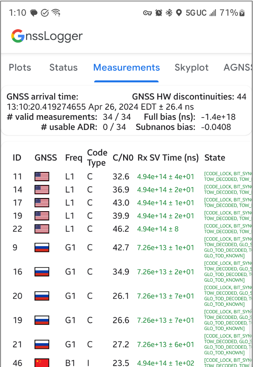
Hình 1. Màn hình Measurements (Đo lường)
Trong thẻ trên cùng:
Ở trên cùng bên trái cho thấy dữ liệu đồng hồ GNSS (tương ứng với GnssClock).
Ở trên cùng bên phải cho thấy số lượng điểm gián đoạn phần cứng (HW) GNSS (từ GnssClock.getHardwareClockDiscontinuityCount), giúp xác định xem chế độ chu kỳ làm việc có đang bật hay không. Khi bộ đếm này tăng lên, điều đó cho biết đã có sự gián đoạn trong quá trình quan sát liên tục các tín hiệu GNSS (ví dụ: chu kỳ làm việc đang bật).
Ở phía dưới, thẻ này hiển thị thông tin tổng hợp cho tất cả các phép đo:
Nếu thiết bị của bạn luôn báo cáo 0 ADR có thể sử dụng, ngay cả khi ở ngoài trời với chế độ chu kỳ làm việc bị tắt, thì đó là dấu hiệu cho thấy thiết bị của bạn không hỗ trợ các phép đo pha sóng mang có thể dùng cho GNSS có độ chính xác cao.
Trong thẻ dưới cùng, mỗi hàng đại diện cho một GnssMeasurement riêng lẻ.
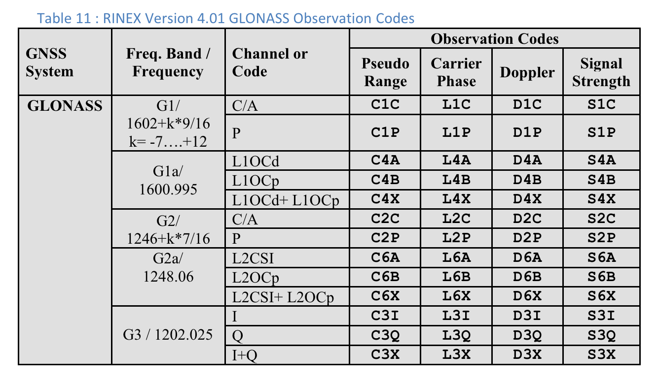
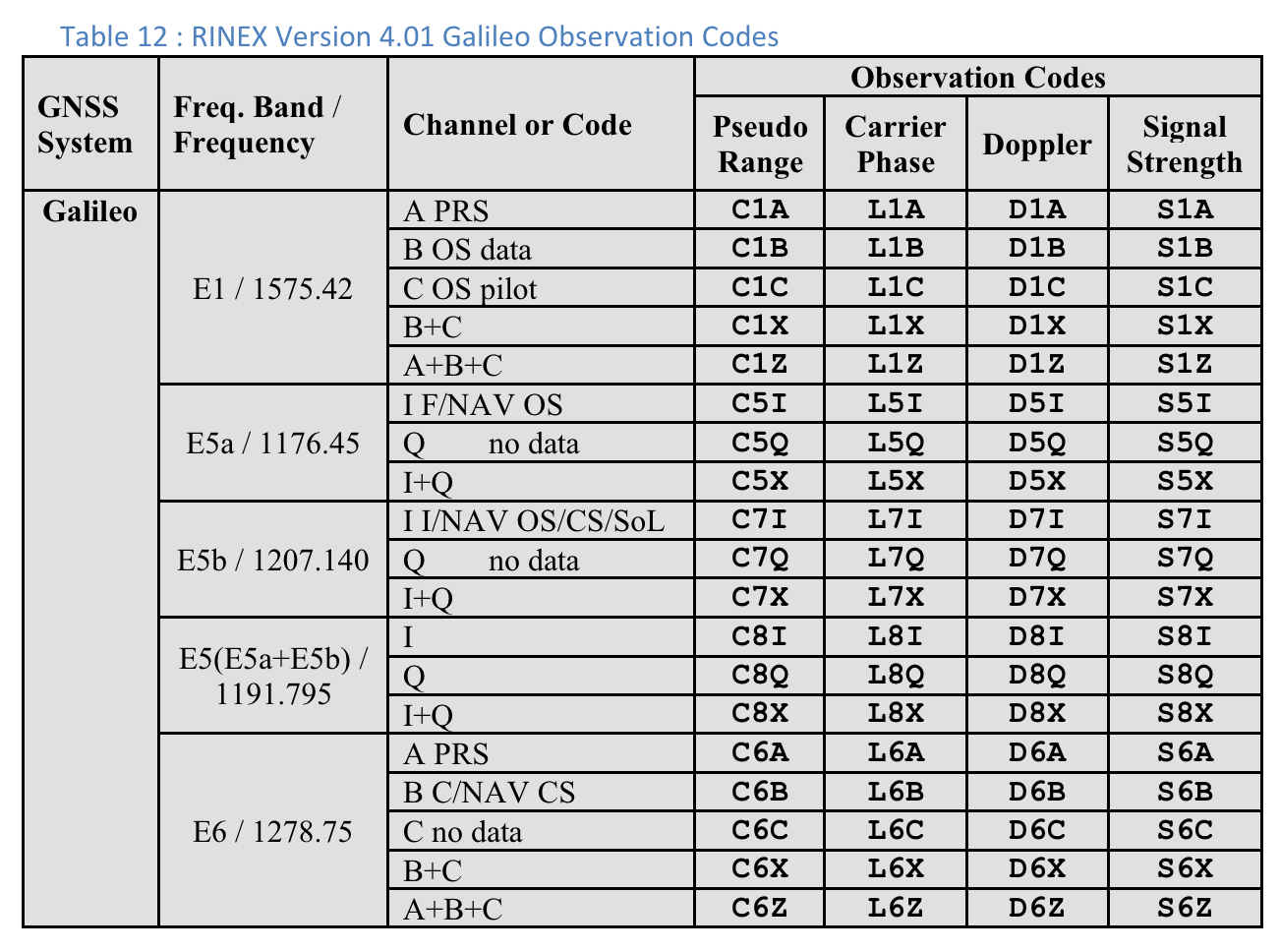
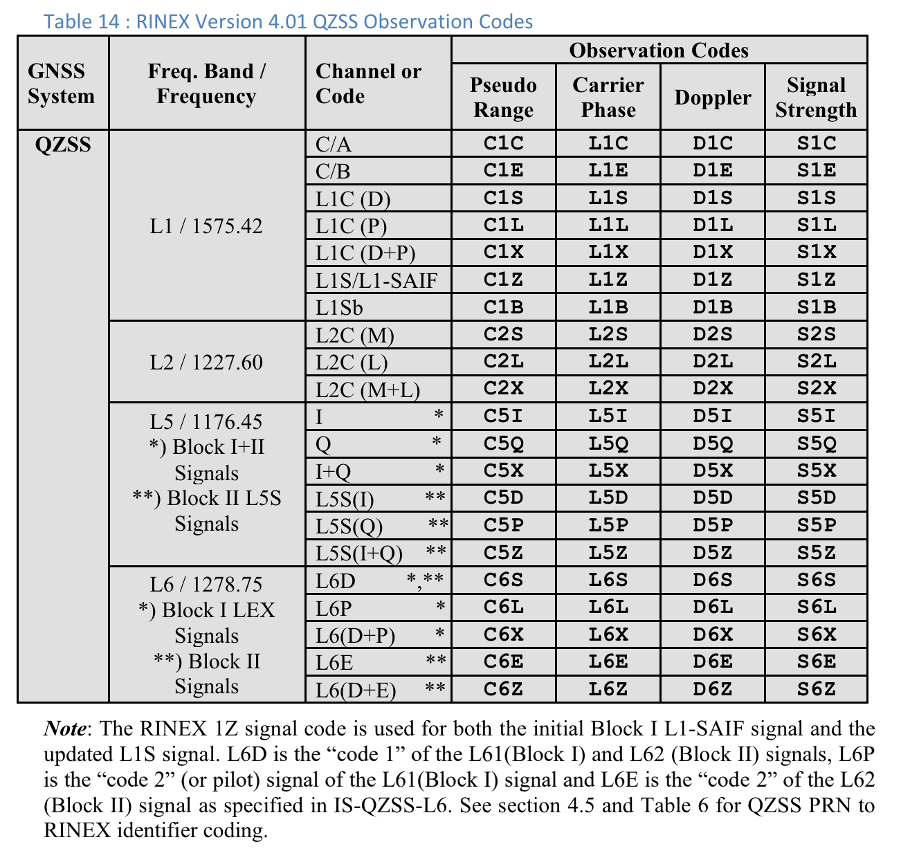
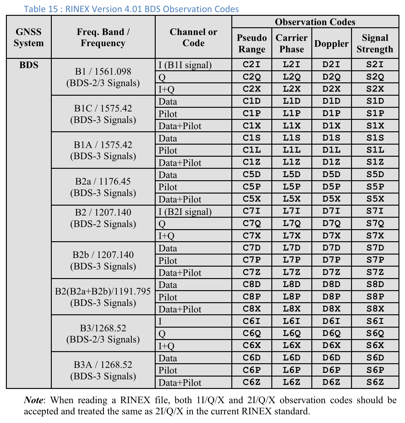
Cột Loại mã cho biết chính xác loại tín hiệu GNSS bằng cách sử dụng các loại mã được xác định trong RINEX 4.01. Ví dụ: tín hiệu GPS L1 có loại mã "C", đại diện cho L1 C/A, như được chỉ định bằng chữ cái cuối cùng trong mã gồm 3 ký tự trong bảng RINEX. Tương tự, GPS L5 Q sẽ có loại mã "Q". Hãy xem các bảng về các cụm sao GNSS khác ở cuối tài liệu này để tham khảo.
Trong cột Thời gian nhận SV (ns), văn bản có màu xanh lục nếu kết quả đo lường là hợp lệ.
Trong cột Trạng thái, trạng thái cũng có màu xanh lục nếu phép đo hợp lệ.
Trạng thái hiển thị phiên bản đọc được bằng mắt thường của các cờ bit được đặt trong trường GnssMeasurement.getState().
Bảng 10 : Mã quan sát GPS theo RINEX Phiên bản 4.01
Đối với mỗi lần đo, "Loại mã" hiển thị là chữ cái cuối cùng của giá trị "Dải giả" được xác định trong quy cách RINEX 4.01 cho hệ thống GNSS và tần số sóng mang có liên quan. Ví dụ: "C" được dùng cho GPS L1 [C/A] còn "Q" được dùng cho GPS L5 Q.
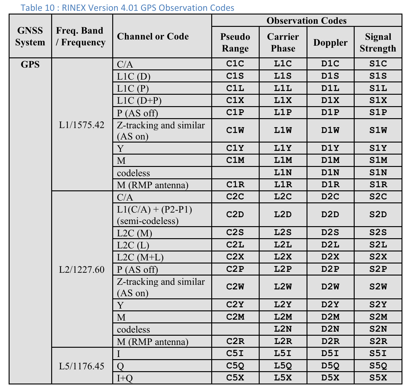
Hình 2. Bảng 10: Mã quan sát GPS RINEX Phiên bản 4.01
Người dùng có thể di chuyển sang phải để xem các cột bổ sung cho từng phép đo:
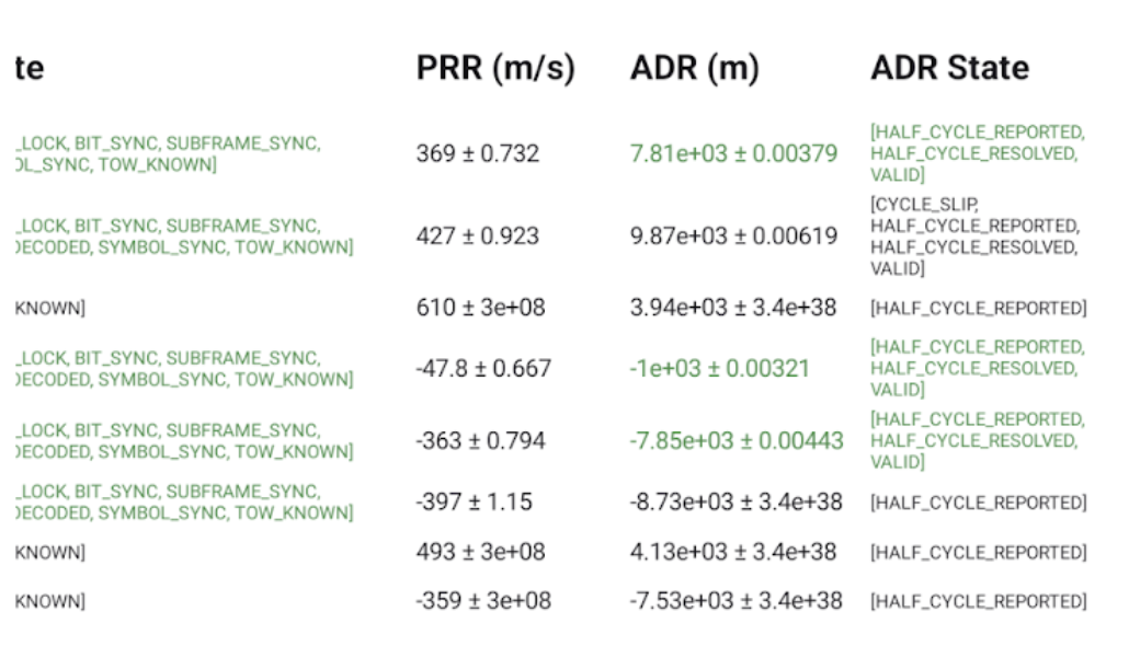
Hình 3. Các cột bổ sung trên màn hình Đo lường trong Bảng 10.
Cột ADR State (Trạng thái ADR) hiển thị phiên bản có thể đọc được của cờ bit được đặt trong cột GnssMeasurement.getAccumulatedDeltaRangeState(). Nếu bạn có thể sử dụng ADR để định vị, thì văn bản trong các trường ADR (m) và Trạng thái ADR sẽ có màu xanh lục.
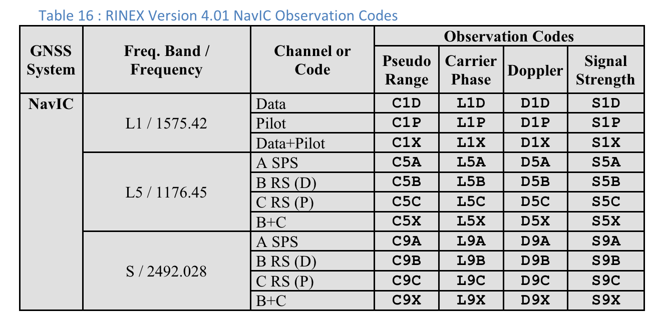
Mã quan sát RINEX 4.01
Ba chữ cái cuối cùng trong mã quan sát RINEX trong cột Phạm vi giả là giá trị Loại mã hiển thị trên màn hình Đo lường trong GnssLogger.
Dưới đây là các bảng trong thông số kỹ thuật RINEX 4.01 để thuận tiện cho bạn.
Hãy xem thông số kỹ thuật đầy đủ để biết thông tin chi tiết.
Hình 4. Bảng 10: Mã quan sát GPS RINEX Phiên bản 4.01Hình 5. Bảng 11: Mã quan sát GLONASS theo RINEX Phiên bản 4.01Hình 6. Bảng 12: Mã quan sát Galileo RINEX Phiên bản 4.01Hình 7. Bảng 13: Mã quan sát SBAS RINEX Phiên bản 4.01Hình 8. Bảng 14: Mã quan sát QZSS RINEX Phiên bản 4.01Hình 9. Bảng 15: Mã quan sát BDS RINEX Phiên bản 4.01Hình 10. Mã quan sát NavIC RINEX Phiên bản 4.01
Nội dung và mã mẫu trên trang này phải tuân thủ các giấy phép như mô tả trong phần Giấy phép nội dung. Java và OpenJDK là nhãn hiệu hoặc nhãn hiệu đã đăng ký của Oracle và/hoặc đơn vị liên kết của Oracle.
Cập nhật lần gần đây nhất: 2025-07-27 UTC.
[[["Dễ hiểu","easyToUnderstand","thumb-up"],["Giúp tôi giải quyết được vấn đề","solvedMyProblem","thumb-up"],["Khác","otherUp","thumb-up"]],[["Thiếu thông tin tôi cần","missingTheInformationINeed","thumb-down"],["Quá phức tạp/quá nhiều bước","tooComplicatedTooManySteps","thumb-down"],["Đã lỗi thời","outOfDate","thumb-down"],["Vấn đề về bản dịch","translationIssue","thumb-down"],["Vấn đề về mẫu/mã","samplesCodeIssue","thumb-down"],["Khác","otherDown","thumb-down"]],["Cập nhật lần gần đây nhất: 2025-07-27 UTC."],[],[],null,["# Analyze raw measurements with GnssLogger\n\nWith GnssLogger v3.1, users can view and analyze raw GNSS data on the\n**Measurements** screen.\n\nHere is the **Measurements** screen, followed by a few tips\nand tricks to make the most out of this data:\n**Figure 1.** Measurements screen\n\nIn the top card:\n\n- The top left shows the GNSS clock data (corresponding to [`GnssClock`](/reference/android/location/GnssClock)).\n- The top right shows the count of GNSS hardware (HW) discontinuities (from [`GnssClock.getHardwareClockDiscontinuityCount`](/reference/android/location/GnssClock#getHardwareClockDiscontinuityCount%28%29)), which helps determine if duty-cycling is on or off. When this counter increments, it indicates that there was a disruption in the continuous observation of GNSS signals (e.g., [duty-cycling](https://barbeau.medium.com/gnss-interrupted-the-hidden-android-setting-you-need-to-know-d812d28a3821) is on). Further down, the card displays aggregate information for all measurements:\n - **# valid measurements** --- For a measurement to be considered valid, the [`STATE_CODE_LOCK`](/reference/android/location/GnssMeasurement#STATE_CODE_LOCK) and [`STATE_TOW_KNOWN`](/reference/android/location/GnssMeasurement#STATE_TOW_KNOWN) or [`STATE_TOW_DECODED`](/reference/android/location/GnssMeasurement#STATE_TOW_DECODED)) flags must be set in [`GnssMeasurement.getState`](/reference/android/location/GnssMeasurement#getState%28%29)().\n - **# usable accumulated delta range (ADR) --- For** ADR, or carrier phase, to be considered usable for positioning, the [`ADR_STATE_VALID`](/reference/android/location/GnssMeasurement#ADR_STATE_VALID) flag must be set and neither the [`ADR_STATE_RESET`](/reference/android/location/GnssMeasurement#ADR_STATE_RESET) nor the [`ADR_STATE_CYCLE_SLIP`](/reference/android/location/GnssMeasurement#ADR_STATE_CYCLE_SLIP) flags can be set in [`GnssMeasurement.getAccumulatedDeltaRangeState`](/reference/android/location/GnssMeasurement#getAccumulatedDeltaRangeState%28%29)().\n\nIf your device always reports 0 usable ADR, even when in open sky with\nduty-cycling disabled, that's a good indication that your\ndevice doesn't support carrier phase measurements that can be used for\nhigh-accuracy GNSS.\n\nIn the bottom card, each row represents an individual [`GnssMeasurement`](/reference/android/location/GnssMeasurement).\n\n- The **Code type** column shows the exact type of GNSS signal using the code types defined in [RINEX 4.01](https://www.igs.org/wg/rinex/). For example, the GPS L1 signals with code type \"C\", represent L1 C/A, as indicated by the last letter in the three character code in the RINEX tables. GPS L5 Q would similarly have a \"Q\" code type. See the tables for other GNSS constellations at the end of this document for reference.\n- In the **Rx SV Time (ns)** column, the text is green if the measurement is valid.\n- In the **State column** , the state is also green if the measurement is valid. State shows a human-readable version of the bitwise flags that are set in the [GnssMeasurement.getState()](/reference/android/location/GnssMeasurement#getState%28%29) field.\n\nProvide feedback on new features using our\n[public issue tracker](https://issuetracker.google.com/issues/new?component=313183&template=0).\n\n**Table 10 : RINEX Version 4.01 GPS Observation Codes**\n\nFor each measurement, the \"Code Type\" shown is the last letter of the \"Pseudo\nRange\" value defined in the RINEX 4.01 specification for the relevant GNSS\nsystem and carrier frequency. For example, \"C\" is used for GPS L1\n\\[C/A\\] while \"Q\" is used for GPS L5 Q.\n**Figure 2.** Table 10: RINEX Version 4.01 GPS Observation Codes\n\nUsers can scroll to the right to see additional columns for each measurement:\n**Figure 3.** Additional columns on the Measurements screen in Table 10.\n\n- **PRR** is the Pseudo Range Rate in meters per second from [GnssMeasurement.getPseudorangeRateMetersPerSecond()](/reference/android/location/GnssMeasurement#getPseudorangeRateMetersPerSecond())\n- The **ADR State** column shows the human-readable version of the bitwise flags set in the [GnssMeasurement.getAccumulatedDeltaRangeState()](/reference/android/location/GnssMeasurement#getAccumulatedDeltaRangeState%28%29) column. If the ADR is usable for positioning, the text in the **ADR (m)** and **ADR State** fields is green.\n\nRINEX 4.01 observation codes\n----------------------------\n\nThe last of the three letters in the RINEX observation codes in the Pseudo Range\ncolumn is the **Code type** value shown on the **Measurements** screen in\nGnssLogger.\n\nFollowing are tables from the [RINEX 4.01 spec](https://www.igs.org/wg/rinex/) for convenience.\nSee the full specification for details.\n**Figure 4.** Table 10: RINEX Version 4.01 GPS Observation Codes **Figure 5.** Table 11: RINEX Version 4.01 GLONASS Observation Codes **Figure 6.** Table 12: RINEX Version 4.01 Galileo Observation Codes **Figure 7.** Table 13: RINEX Version 4.01 SBAS Observation Codes **Figure 8.** Table 14: RINEX Version 4.01 QZSS Observation Codes **Figure 9.** Table 15: RINEX Version 4.01 BDS Observation Codes **Figure 10.** RINEX Version 4.01 NavIC Observation Codes"]]