اندازه گیری های خام را با GnssLogger تجزیه و تحلیل کنید
با مجموعهها، منظم بمانید
ذخیره و طبقهبندی محتوا براساس اولویتهای شما.
با GnssLogger نسخه 3.1، کاربران می توانند داده های خام GNSS را در صفحه اندازه گیری مشاهده و تجزیه و تحلیل کنند.
در اینجا صفحه اندازهگیری وجود دارد که به دنبال آن چند نکته و ترفند برای استفاده حداکثری از این دادهها وجود دارد:
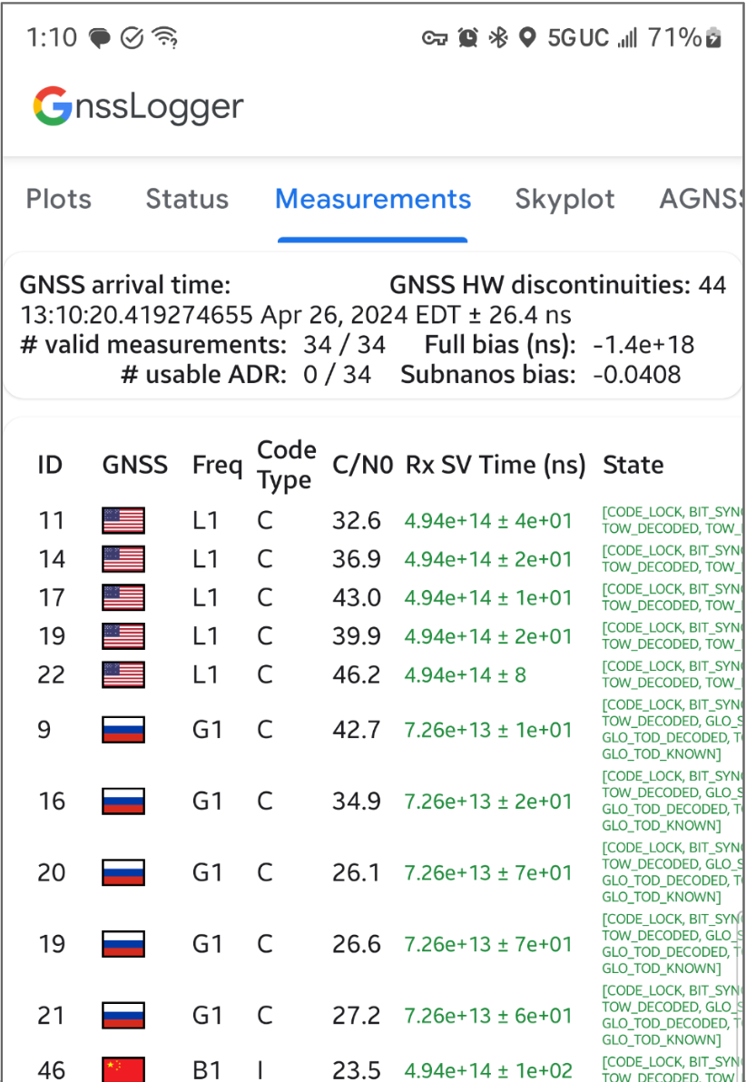
شکل 1. صفحه اندازه گیری
در کارت بالا:
بالا سمت چپ داده های ساعت GNSS (مرتبط با GnssClock ) را نشان می دهد.
سمت راست بالا تعداد ناپیوستگیهای سختافزار GNSS (HW) را نشان میدهد (از GnssClock.getHardwareClockDiscontinuityCount )، که به تعیین روشن یا خاموش بودن چرخه کاری کمک میکند. هنگامی که این شمارنده افزایش می یابد، نشان می دهد که اختلالی در مشاهده مداوم سیگنال های GNSS وجود دارد (به عنوان مثال، چرخه کاری روشن است). در پایین تر، کارت اطلاعات کلی را برای همه اندازه گیری ها نمایش می دهد:
اگر دستگاه شما همیشه 0 ADR قابل استفاده را گزارش میکند، حتی زمانی که در آسمان باز با چرخه کاری غیرفعال است، این نشانه خوبی است که دستگاه شما از اندازهگیری فاز حامل که میتواند برای GNSS با دقت بالا استفاده شود، پشتیبانی نمیکند.
ستون نوع کد نوع دقیق سیگنال GNSS را با استفاده از انواع کد تعریف شده در RINEX 4.01 نشان می دهد. به عنوان مثال، سیگنال های GPS L1 با نوع کد "C"، نشان دهنده L1 C/A است که با حرف آخر در کد سه کاراکتری در جداول RINEX نشان داده شده است. GPS L5 Q به طور مشابه دارای یک نوع کد "Q" خواهد بود. برای ارجاع به جداول دیگر صورت فلکی GNSS در انتهای این سند مراجعه کنید.
در ستون Rx SV Time (ns) ، اگر اندازه گیری معتبر باشد، متن سبز است.
در ستون State ، اگر اندازه گیری معتبر باشد، وضعیت نیز سبز است. State یک نسخه قابل خواندن توسط انسان از پرچمهای بیتی را نشان میدهد که در فیلد ()GnssMeasurement.getState تنظیم شدهاند.
با استفاده از ردیاب مسائل عمومی ما درباره ویژگیهای جدید بازخورد ارائه کنید.
جدول 10: RINEX نسخه 4.01 کدهای مشاهده GPS
برای هر اندازه گیری، "نوع کد" نشان داده شده، آخرین حرف مقدار "محدوده شبه" است که در مشخصات RINEX 4.01 برای سیستم GNSS مربوطه و فرکانس حامل تعریف شده است. به عنوان مثال، "C" برای GPS L1 [C/A] استفاده می شود در حالی که از "Q" برای GPS L5 Q استفاده می شود.
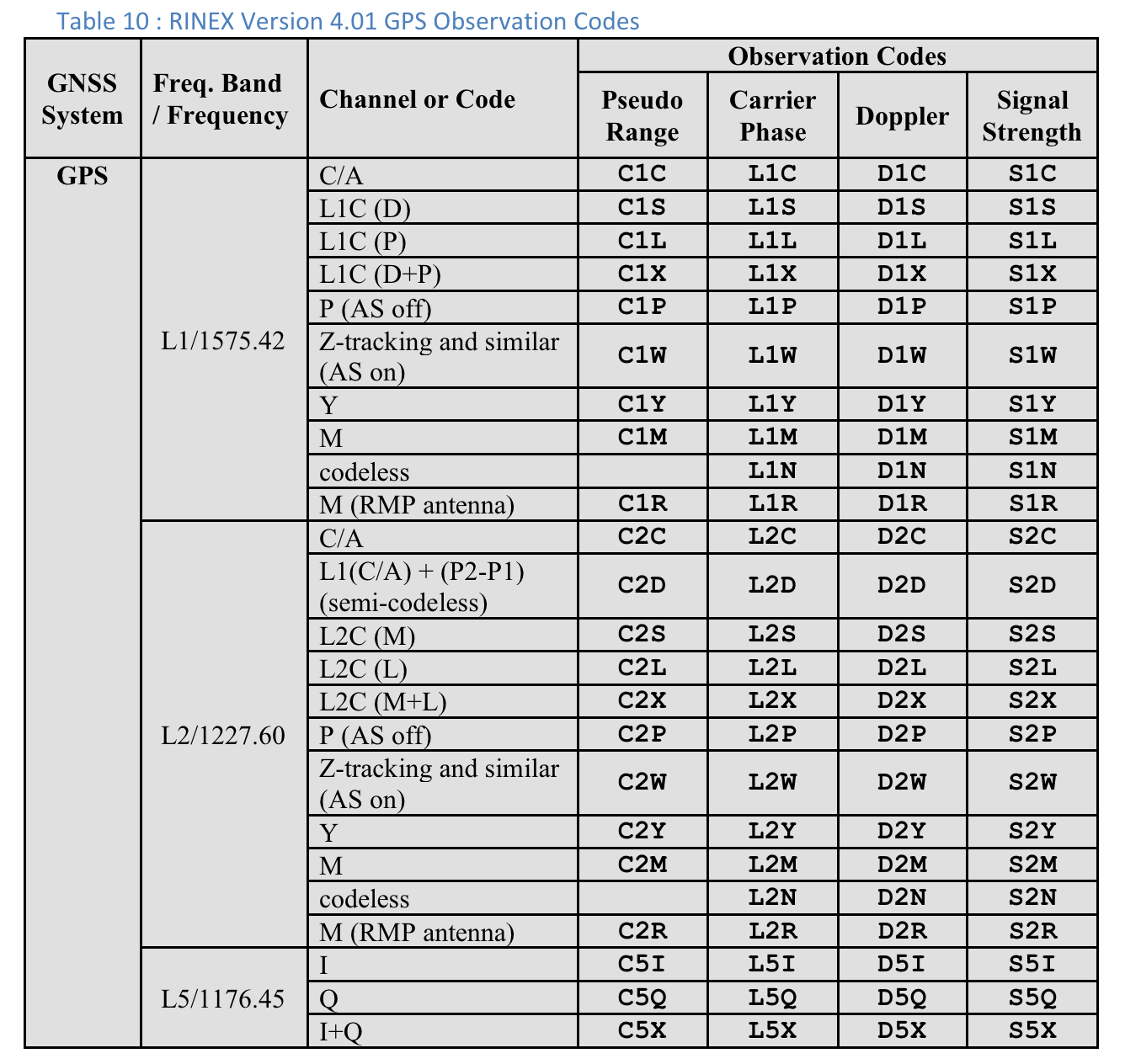
شکل 2. جدول 10: RINEX نسخه 4.01 کدهای مشاهده GPS
کاربران می توانند برای دیدن ستون های اضافی برای هر اندازه گیری به سمت راست حرکت کنند:
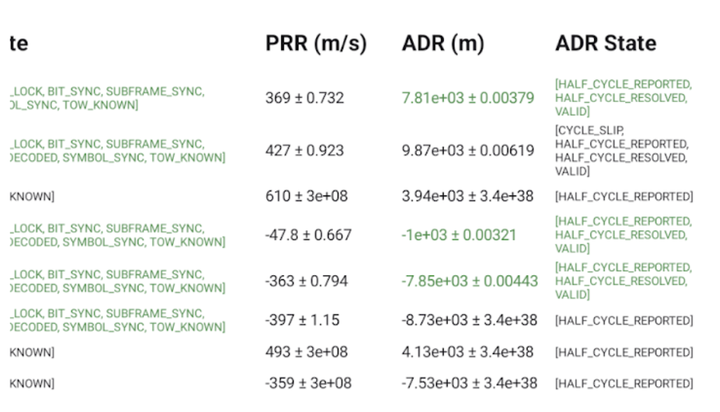
شکل 3. ستون های اضافی در صفحه اندازه گیری در جدول 10.
ستون ADR State نسخه قابل خواندن توسط انسان پرچمهای بیتی تنظیم شده در ستون ()GnssMeasurement.getAccumulatedDeltaRangeState را نشان میدهد. اگر ADR برای موقعیت یابی قابل استفاده باشد، متن در فیلدهای ADR (m) و وضعیت ADR سبز است.
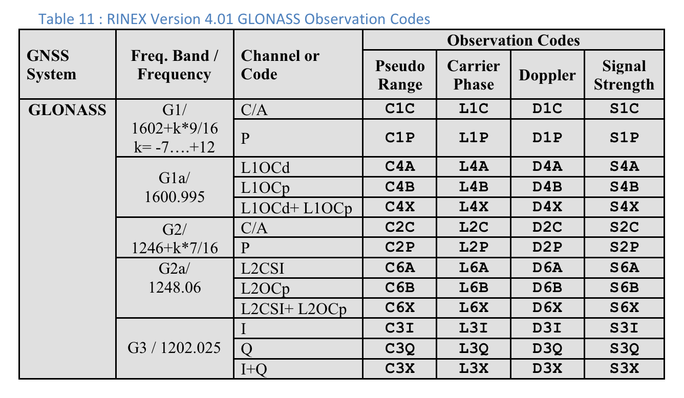
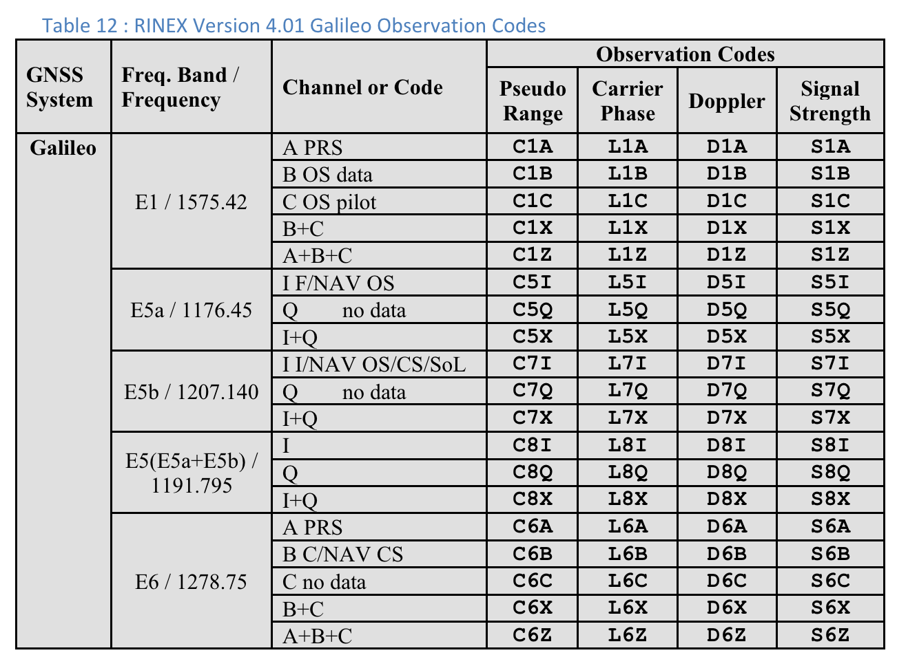
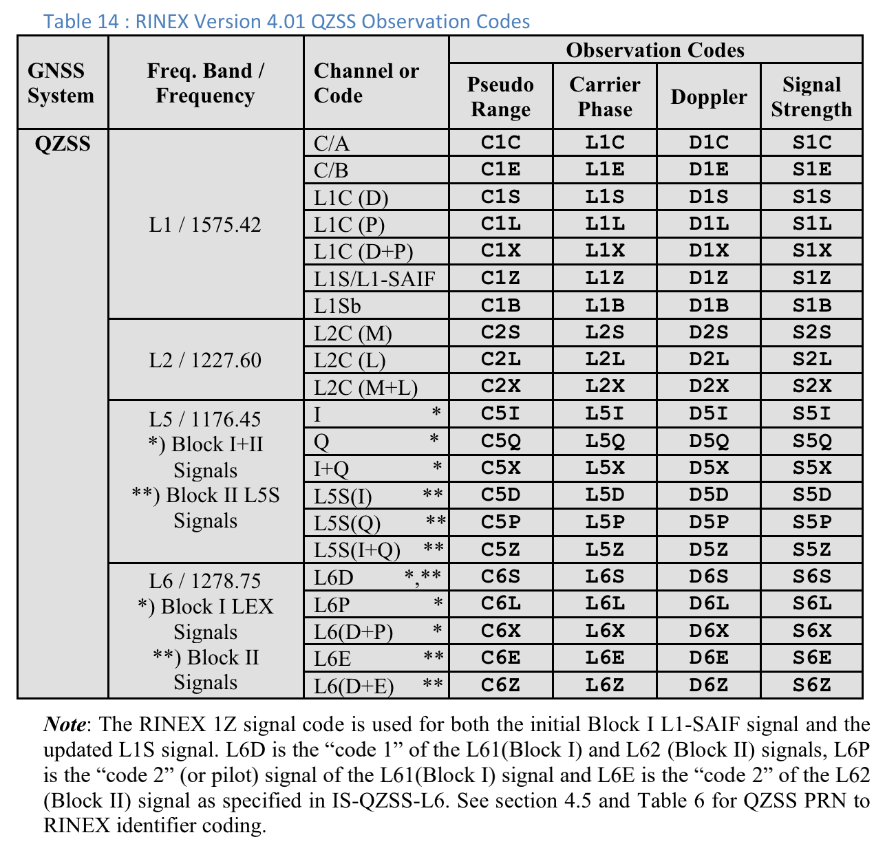
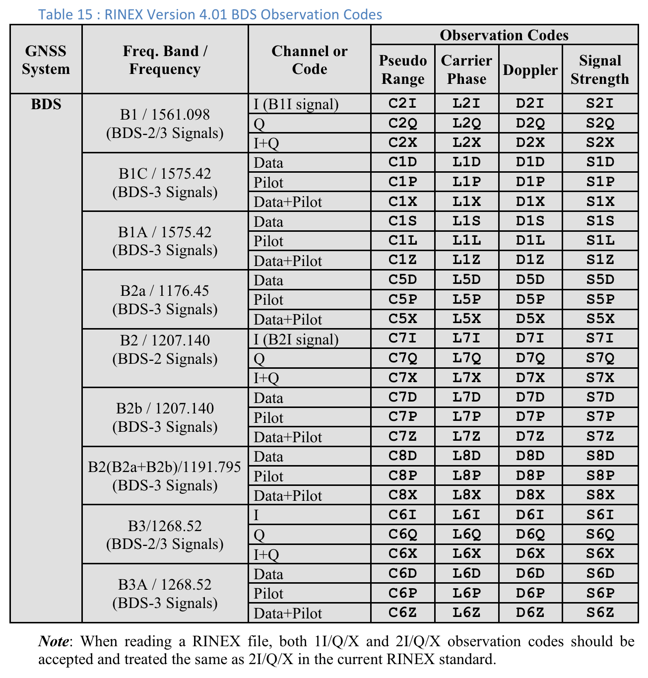
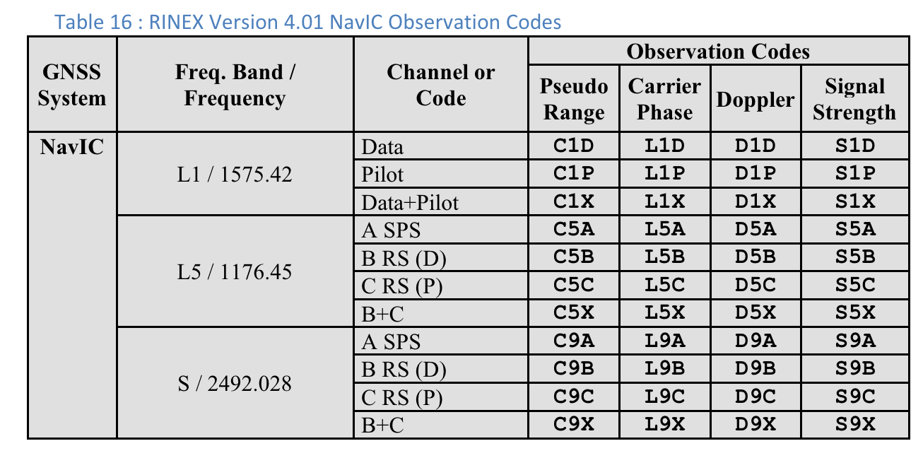
کدهای مشاهده RINEX 4.01
آخرین حرف از سه حرف در کدهای مشاهده RINEX در ستون Pseudo Range مقدار نوع کد است که در صفحه اندازهگیریها در GnssLogger نشان داده شده است.
در زیر جداول از مشخصات RINEX 4.01 برای راحتی وجود دارد. مشخصات کامل را برای جزئیات ببینید.
شکل 4. جدول 10: RINEX نسخه 4.01 کدهای مشاهده GPS شکل 5. جدول 11: RINEX نسخه 4.01 کدهای مشاهده گلوناس شکل 6. جدول 12: RINEX نسخه 4.01 کدهای مشاهده گالیله شکل 7. جدول 13: RINEX نسخه 4.01 کدهای مشاهده SBAS شکل 8. جدول 14: RINEX نسخه 4.01 کدهای مشاهده QZSS شکل 9. جدول 15: RINEX نسخه 4.01 کدهای مشاهده BDS شکل 10. RINEX نسخه 4.01 کدهای مشاهده NavIC
محتوا و نمونه کدها در این صفحه مشمول پروانههای توصیفشده در پروانه محتوا هستند. جاوا و OpenJDK علامتهای تجاری یا علامتهای تجاری ثبتشده Oracle و/یا وابستههای آن هستند.
تاریخ آخرین بهروزرسانی 2025-07-29 بهوقت ساعت هماهنگ جهانی.
[[["درک آسان","easyToUnderstand","thumb-up"],["مشکلم را برطرف کرد","solvedMyProblem","thumb-up"],["غیره","otherUp","thumb-up"]],[["اطلاعاتی که نیاز دارم وجود ندارد","missingTheInformationINeed","thumb-down"],["بیشازحد پیچیده/ مراحل بسیار زیاد","tooComplicatedTooManySteps","thumb-down"],["قدیمی","outOfDate","thumb-down"],["مشکل ترجمه","translationIssue","thumb-down"],["مشکل کد / نمونهها","samplesCodeIssue","thumb-down"],["غیره","otherDown","thumb-down"]],["تاریخ آخرین بهروزرسانی 2025-07-29 بهوقت ساعت هماهنگ جهانی."],[],[],null,["# Analyze raw measurements with GnssLogger\n\nWith GnssLogger v3.1, users can view and analyze raw GNSS data on the\n**Measurements** screen.\n\nHere is the **Measurements** screen, followed by a few tips\nand tricks to make the most out of this data:\n**Figure 1.** Measurements screen\n\nIn the top card:\n\n- The top left shows the GNSS clock data (corresponding to [`GnssClock`](/reference/android/location/GnssClock)).\n- The top right shows the count of GNSS hardware (HW) discontinuities (from [`GnssClock.getHardwareClockDiscontinuityCount`](/reference/android/location/GnssClock#getHardwareClockDiscontinuityCount%28%29)), which helps determine if duty-cycling is on or off. When this counter increments, it indicates that there was a disruption in the continuous observation of GNSS signals (e.g., [duty-cycling](https://barbeau.medium.com/gnss-interrupted-the-hidden-android-setting-you-need-to-know-d812d28a3821) is on). Further down, the card displays aggregate information for all measurements:\n - **# valid measurements** --- For a measurement to be considered valid, the [`STATE_CODE_LOCK`](/reference/android/location/GnssMeasurement#STATE_CODE_LOCK) and [`STATE_TOW_KNOWN`](/reference/android/location/GnssMeasurement#STATE_TOW_KNOWN) or [`STATE_TOW_DECODED`](/reference/android/location/GnssMeasurement#STATE_TOW_DECODED)) flags must be set in [`GnssMeasurement.getState`](/reference/android/location/GnssMeasurement#getState%28%29)().\n - **# usable accumulated delta range (ADR) --- For** ADR, or carrier phase, to be considered usable for positioning, the [`ADR_STATE_VALID`](/reference/android/location/GnssMeasurement#ADR_STATE_VALID) flag must be set and neither the [`ADR_STATE_RESET`](/reference/android/location/GnssMeasurement#ADR_STATE_RESET) nor the [`ADR_STATE_CYCLE_SLIP`](/reference/android/location/GnssMeasurement#ADR_STATE_CYCLE_SLIP) flags can be set in [`GnssMeasurement.getAccumulatedDeltaRangeState`](/reference/android/location/GnssMeasurement#getAccumulatedDeltaRangeState%28%29)().\n\nIf your device always reports 0 usable ADR, even when in open sky with\nduty-cycling disabled, that's a good indication that your\ndevice doesn't support carrier phase measurements that can be used for\nhigh-accuracy GNSS.\n\nIn the bottom card, each row represents an individual [`GnssMeasurement`](/reference/android/location/GnssMeasurement).\n\n- The **Code type** column shows the exact type of GNSS signal using the code types defined in [RINEX 4.01](https://www.igs.org/wg/rinex/). For example, the GPS L1 signals with code type \"C\", represent L1 C/A, as indicated by the last letter in the three character code in the RINEX tables. GPS L5 Q would similarly have a \"Q\" code type. See the tables for other GNSS constellations at the end of this document for reference.\n- In the **Rx SV Time (ns)** column, the text is green if the measurement is valid.\n- In the **State column** , the state is also green if the measurement is valid. State shows a human-readable version of the bitwise flags that are set in the [GnssMeasurement.getState()](/reference/android/location/GnssMeasurement#getState%28%29) field.\n\nProvide feedback on new features using our\n[public issue tracker](https://issuetracker.google.com/issues/new?component=313183&template=0).\n\n**Table 10 : RINEX Version 4.01 GPS Observation Codes**\n\nFor each measurement, the \"Code Type\" shown is the last letter of the \"Pseudo\nRange\" value defined in the RINEX 4.01 specification for the relevant GNSS\nsystem and carrier frequency. For example, \"C\" is used for GPS L1\n\\[C/A\\] while \"Q\" is used for GPS L5 Q.\n**Figure 2.** Table 10: RINEX Version 4.01 GPS Observation Codes\n\nUsers can scroll to the right to see additional columns for each measurement:\n**Figure 3.** Additional columns on the Measurements screen in Table 10.\n\n- **PRR** is the Pseudo Range Rate in meters per second from [GnssMeasurement.getPseudorangeRateMetersPerSecond()](/reference/android/location/GnssMeasurement#getPseudorangeRateMetersPerSecond())\n- The **ADR State** column shows the human-readable version of the bitwise flags set in the [GnssMeasurement.getAccumulatedDeltaRangeState()](/reference/android/location/GnssMeasurement#getAccumulatedDeltaRangeState%28%29) column. If the ADR is usable for positioning, the text in the **ADR (m)** and **ADR State** fields is green.\n\nRINEX 4.01 observation codes\n----------------------------\n\nThe last of the three letters in the RINEX observation codes in the Pseudo Range\ncolumn is the **Code type** value shown on the **Measurements** screen in\nGnssLogger.\n\nFollowing are tables from the [RINEX 4.01 spec](https://www.igs.org/wg/rinex/) for convenience.\nSee the full specification for details.\n**Figure 4.** Table 10: RINEX Version 4.01 GPS Observation Codes **Figure 5.** Table 11: RINEX Version 4.01 GLONASS Observation Codes **Figure 6.** Table 12: RINEX Version 4.01 Galileo Observation Codes **Figure 7.** Table 13: RINEX Version 4.01 SBAS Observation Codes **Figure 8.** Table 14: RINEX Version 4.01 QZSS Observation Codes **Figure 9.** Table 15: RINEX Version 4.01 BDS Observation Codes **Figure 10.** RINEX Version 4.01 NavIC Observation Codes"]]