เมื่อใช้ GnssLogger v3.1 ผู้ใช้จะดูและวิเคราะห์ข้อมูล GNSS ดิบในหน้าจอการวัดได้
หน้าจอการวัดพร้อมเคล็ดลับและกลเม็ดในการใช้ประโยชน์จากข้อมูลนี้ให้คุ้มค่าที่สุด
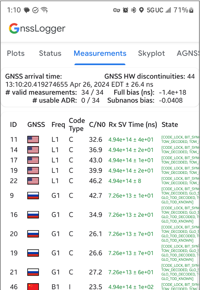
ในการ์ดด้านบน ให้ทำดังนี้
- ด้านบนซ้ายแสดงข้อมูลนาฬิกา GNSS (สอดคล้องกับ
GnssClock) - ด้านบนขวาแสดงจํานวนการหยุดชะงักของฮาร์ดแวร์ (HW) GNSS (จาก
GnssClock.getHardwareClockDiscontinuityCount) ซึ่งช่วยระบุว่าโหมดการทำงานแบบเปิด/ปิดเปิดหรือปิดอยู่ เมื่อตัวนับนี้เพิ่มขึ้น แสดงว่ามีการหยุดชะงักในการสังเกตสัญญาณ GNSS อย่างต่อเนื่อง (เช่น โหมดการทำงานแบบเปิด/ปิดเปิดอยู่) ด้านล่าง การ์ดจะแสดงข้อมูลรวมของการวัดผลทั้งหมด ดังนี้- # การวัดผลที่ถูกต้อง — หากต้องการให้การวัดผลถือว่าถูกต้อง คุณต้องตั้งค่า Flag
STATE_CODE_LOCKและSTATE_TOW_KNOWNหรือSTATE_TOW_DECODEDในGnssMeasurement.getState - # ช่วงเดลต้าสะสมที่ใช้งานได้ (ADR) — หากต้องการให้ ADR หรือเฟสของสัญญาณดาวเทียมถือว่าใช้งานได้สำหรับการระบุตำแหน่ง คุณต้องตั้งค่า Flag
ADR_STATE_VALIDและจะต้องไม่ตั้งค่า FlagADR_STATE_RESETหรือADR_STATE_CYCLE_SLIPในGnssMeasurement.getAccumulatedDeltaRangeState
- # การวัดผลที่ถูกต้อง — หากต้องการให้การวัดผลถือว่าถูกต้อง คุณต้องตั้งค่า Flag
หากอุปกรณ์รายงาน ADR ที่ใช้งานได้เป็น 0 เสมอ แม้ว่าจะอยู่กลางแจ้งโดยปิดใช้วงจรการทำงานแบบเปิด/ปิดก็ตาม แสดงว่าอุปกรณ์ไม่รองรับการวัดเฟสของสัญญาณที่สามารถใช้กับ GNSS ที่มีความแม่นยำสูง
ในการ์ดด้านล่าง แต่ละแถวแสดง GnssMeasurement แต่ละรายการ
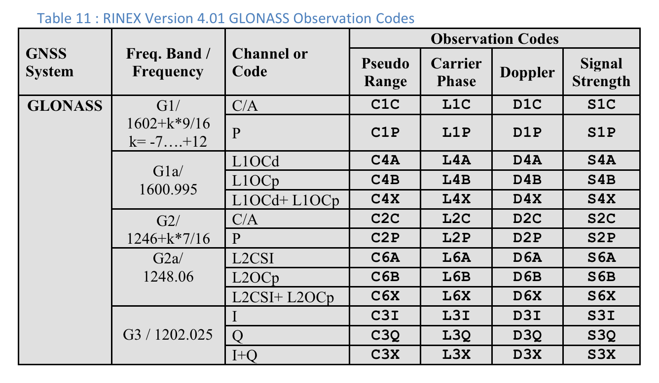
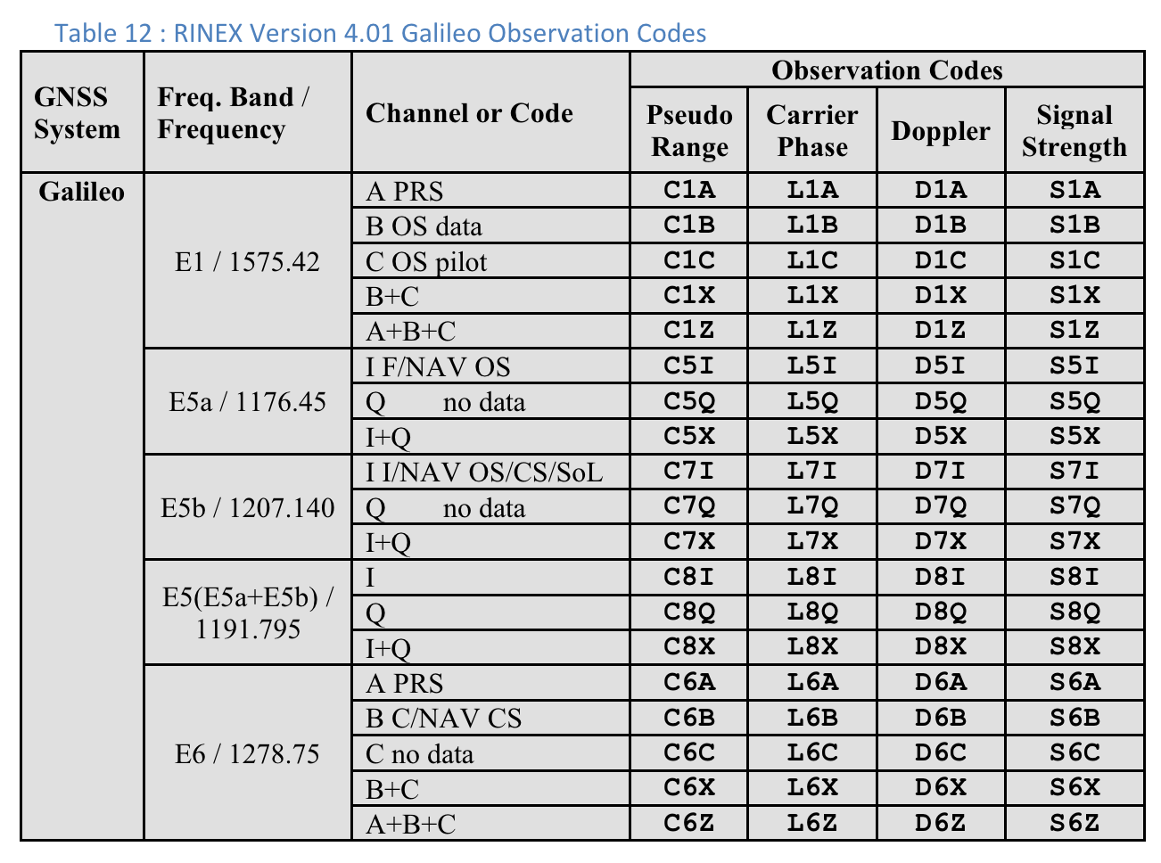
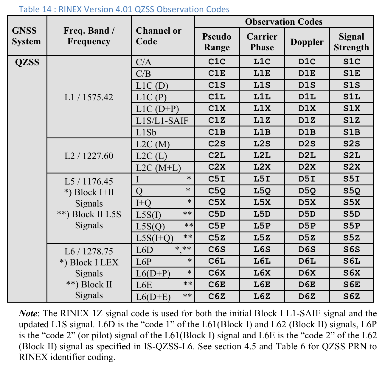
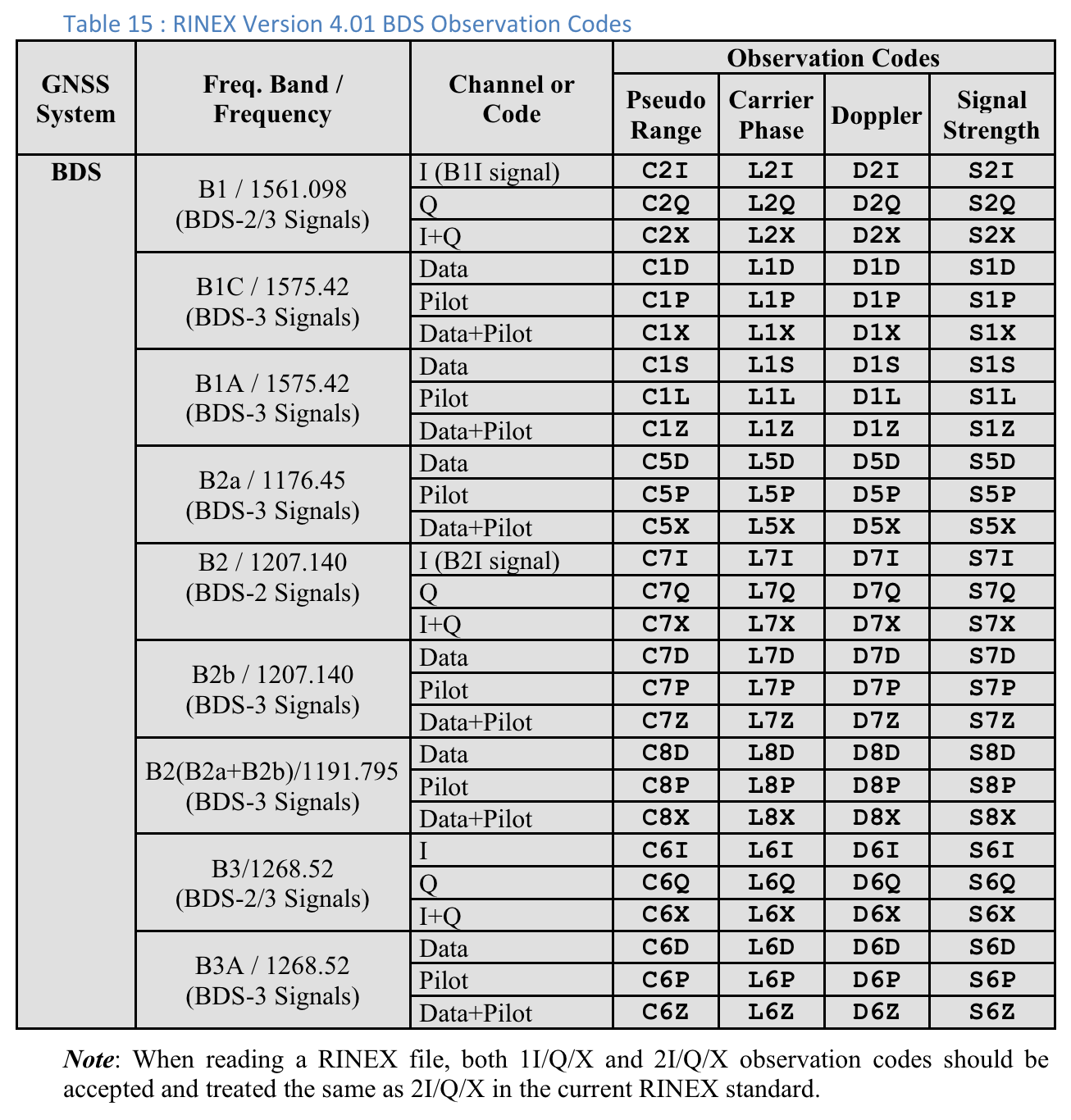
- คอลัมน์ประเภทรหัสแสดงประเภทสัญญาณ GNSS ที่แน่นอนโดยใช้ประเภทรหัสที่ระบุไว้ใน RINEX 4.01 เช่น สัญญาณ L1 ของ GPS ที่มีประเภทโค้ด "C" จะแสดงถึง L1 C/A ตามที่ระบุโดยตัวอักษรสุดท้ายในโค้ด 3 อักขระในตาราง RINEX GPS L5 Q จะมีประเภทรหัสเป็น "Q" ในทำนองเดียวกัน ดูตารางกลุ่มดาว GNSS อื่นๆ ที่ส่วนท้ายของเอกสารนี้เพื่อใช้เป็นข้อมูลอ้างอิง
- ในคอลัมน์ Rx SV Time (ns) ข้อความจะเป็นสีเขียวหากการวัดผลถูกต้อง
- ในคอลัมน์สถานะ สถานะจะเป็นสีเขียวด้วยหากการวัดผลถูกต้อง สถานะแสดง Flag แบบบิตต่อบิตในเวอร์ชันที่มนุษย์อ่านได้ซึ่งตั้งค่าไว้ในช่อง GnssMeasurement.getState()
แสดงความคิดเห็นเกี่ยวกับฟีเจอร์ใหม่โดยใช้เครื่องมือติดตามปัญหาสาธารณะ
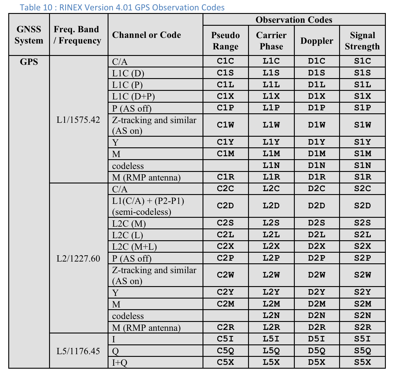
ตารางที่ 10 : รหัสการสังเกตการณ์ GPS เวอร์ชัน 4.01 ของ RINEX
"ประเภทรหัส" ที่แสดงสําหรับการวัดแต่ละครั้งคือตัวอักษรสุดท้ายของค่า "Pseudo ranged" ที่กําหนดไว้ในข้อกําหนด RINEX 4.01 สําหรับระบบ GNSS ที่เกี่ยวข้องและความถี่ของสัญญาณรบกวน เช่น "C" ใช้สำหรับ GPS L1 [C/A] ส่วน "Q" ใช้สำหรับ GPS L5 Q
ผู้ใช้สามารถเลื่อนไปทางขวาเพื่อดูคอลัมน์เพิ่มเติมสำหรับการวัดผลแต่ละรายการ ดังนี้
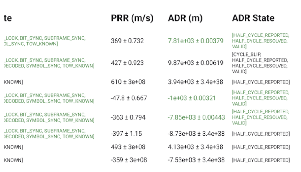
- PRR คืออัตราพิสัยเสมือนเป็นเมตรต่อวินาทีจาก GnssMeasurement.getPseudorangeRateMetersPerSecond()
- คอลัมน์สถานะ ADR แสดง Flag แบบบิตต่อบิตที่ผู้ใช้อ่านได้ซึ่งตั้งค่าไว้ในคอลัมน์ GnssMeasurement.getAccumulatedDeltaRangeState() หาก ADR ใช้ได้กับตําแหน่ง ข้อความในช่อง ADR (m) และ ADR State จะเปลี่ยนเป็นสีเขียว
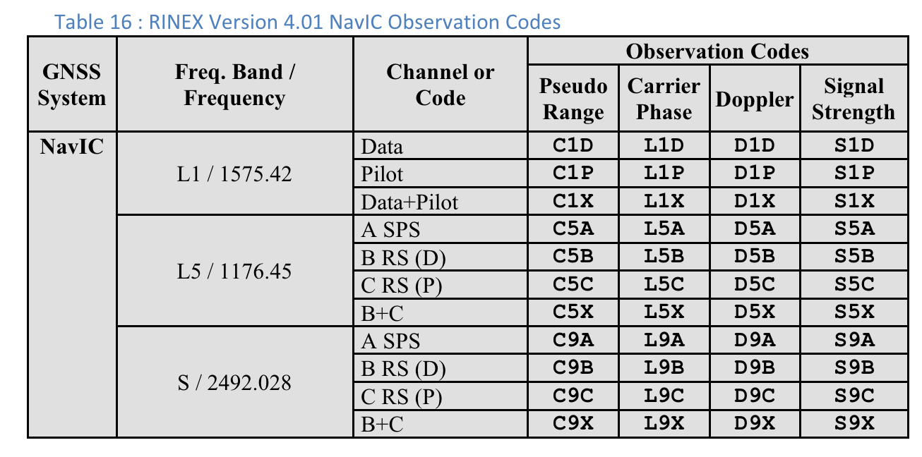
รหัสการสังเกตการณ์ RINEX 4.01
อักษรตัวสุดท้ายใน 3 ตัวในรหัสการสังเกตการณ์ RINEX ในคอลัมน์ช่วงเสมือนคือค่าประเภทรหัสที่แสดงในหน้าจอการวัดใน GnssLogger
ตารางต่อไปนี้เป็นตารางจากข้อกำหนด RINEX 4.01 เพื่อความสะดวก ดูรายละเอียดได้ในข้อกำหนดฉบับเต็ม

