Mantenha tudo organizado com as coleções
Salve e categorize o conteúdo com base nas suas preferências.
Com o GnssLogger v3.1, os usuários podem conferir e analisar dados GNSS brutos na tela
Medições.
Esta é a tela Medições, seguida de algumas dicas e truques para aproveitar ao máximo esses dados:
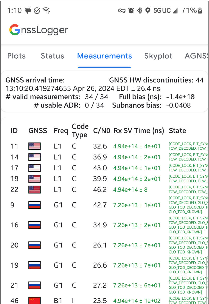
Figura 1. Tela "Medições"
No card de cima:
O canto superior esquerdo mostra os dados do relógio GNSS (correspondentes a GnssClock).
No canto superior direito, é mostrada a contagem de descontinuidades de hardware (HW) do GNSS (de
GnssClock.getHardwareClockDiscontinuityCount), que ajuda a determinar se
o ciclo de trabalho está ativado ou desativado. Quando esse contador aumenta, ele indica que
houve uma interrupção na observação contínua dos sinais do GNSS (por exemplo,
o ciclo de trabalho está ativado).
Mais abaixo, o card mostra informações agregadas de todas as medições:
Se o dispositivo sempre informar 0 ADR utilizável, mesmo em céu aberto com
ciclo de trabalho desativado, isso indica que ele
não oferece suporte a medições de fase de portador que podem ser usadas para
GNSS de alta precisão.
No card de baixo, cada linha representa um GnssMeasurement individual.
A coluna Tipo de código mostra o tipo exato de sinal GNSS usando os tipos de código definidos no RINEX 4.01. Por exemplo, os sinais do GPS L1
com o tipo de código "C" representam L1 C/A, conforme indicado pela última letra no
código de três caracteres nas tabelas RINEX. O GPS L5 Q também teria um tipo de código "Q". Consulte as tabelas de outras constelações do GNSS no final deste
documento para referência.
Na coluna Rx SV Time (ns), o texto fica verde se a medição for
válida.
Na coluna Estado, o estado também é verde se a medição for válida.
O estado mostra uma versão legível por humanos das flags binárias definidas no campo
GnssMeasurement.getState().
Tabela 10 : códigos de observação do GPS do RINEX, versão 4.01
Para cada medição, o "Tipo de código" mostrado é a última letra do valor "Pseudorange" definido na especificação RINEX 4.01 para o sistema GNSS relevante e a frequência do portador. Por exemplo, "C" é usado para GPS L1
[C/A], enquanto "Q" é usado para GPS L5 Q.
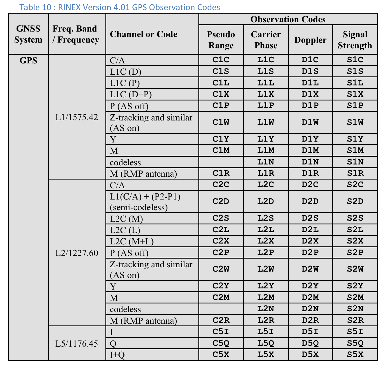
Figura 2. Tabela 10: códigos de observação de GPS do RINEX versão 4.01
Os usuários podem rolar para a direita para conferir outras colunas de cada medição:
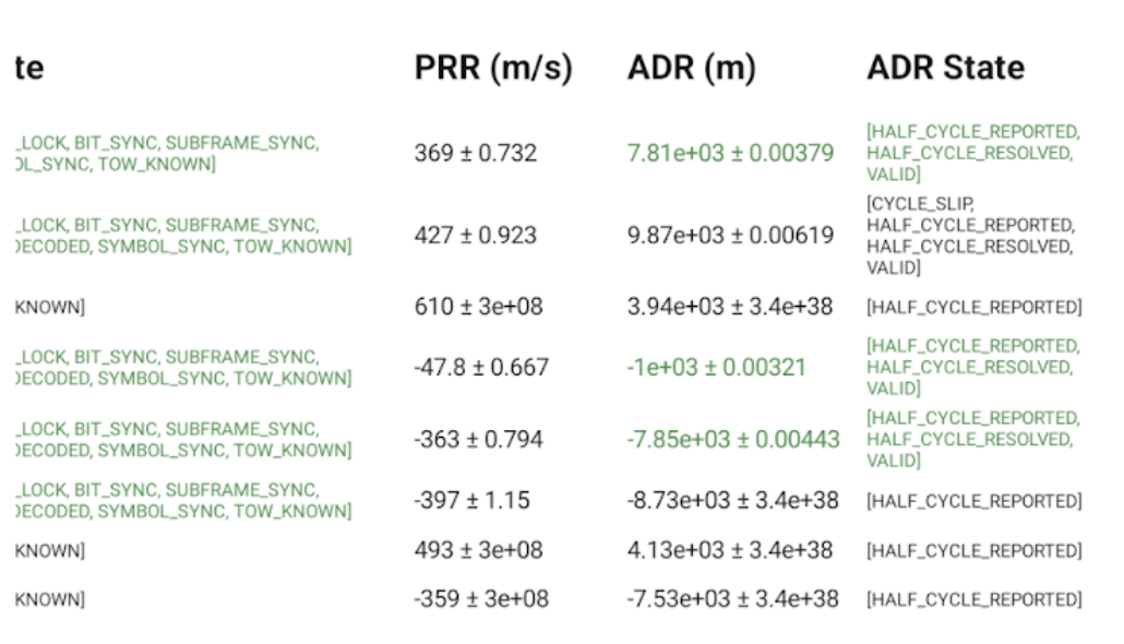
Figura 3. Colunas adicionais na tela "Medições" na Tabela 10.
A coluna ADR State mostra a versão legível por humanos das flags de bit
definidas na coluna GnssMeasurement.getAccumulatedDeltaRangeState(). Se
o ADR puder ser usado para posicionamento, o texto nos campos ADR (m) e
Estado do ADR será verde.
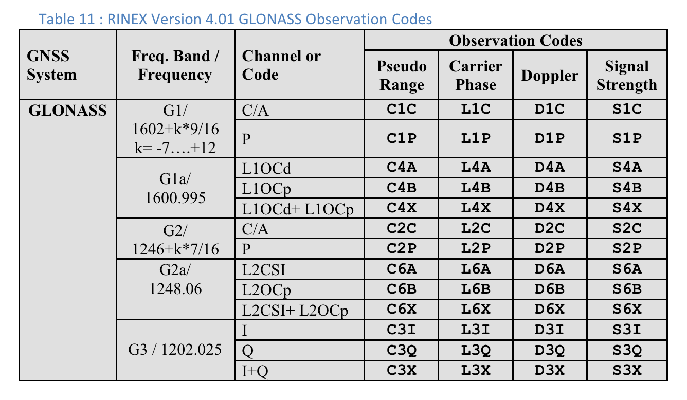
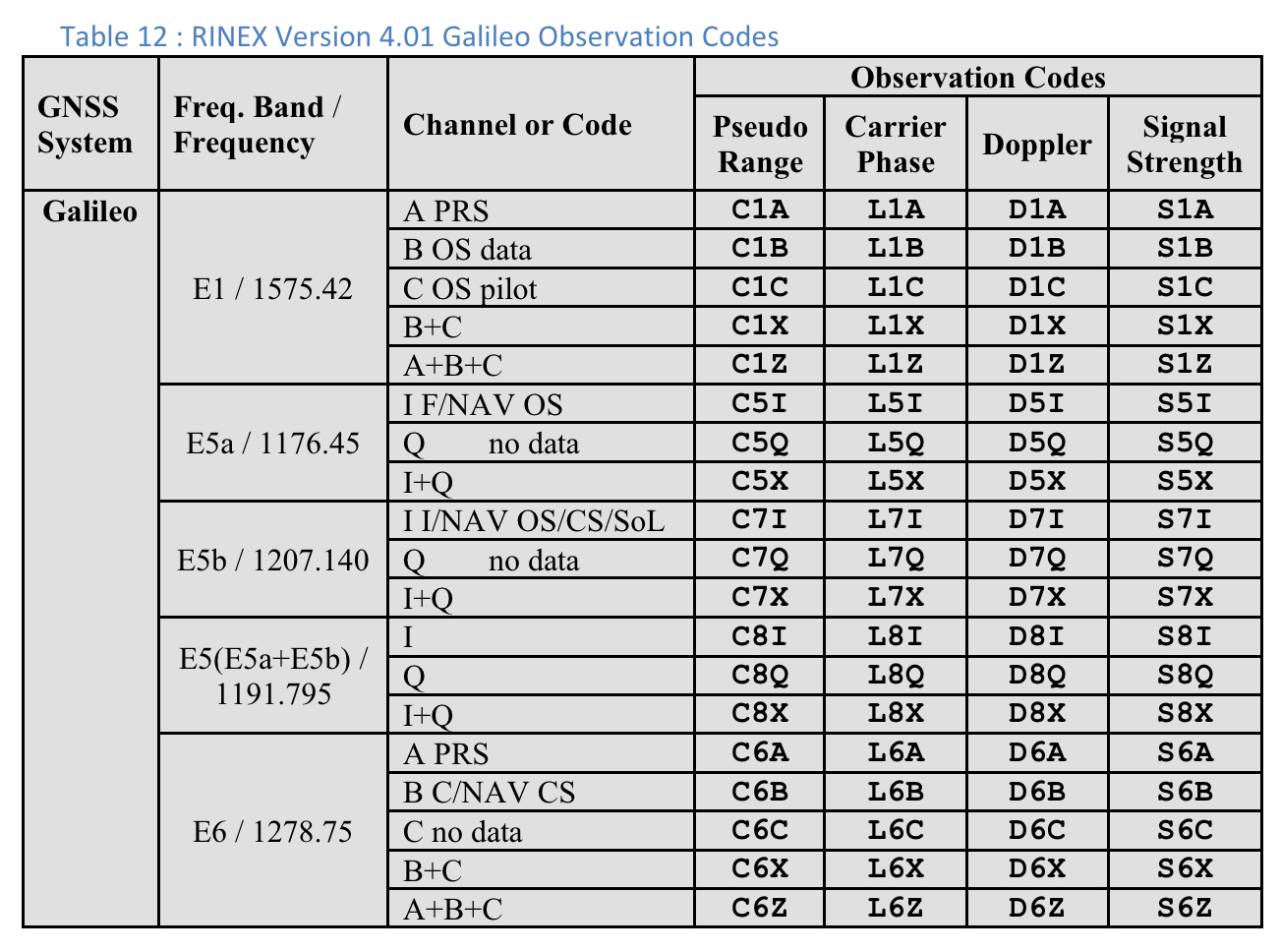
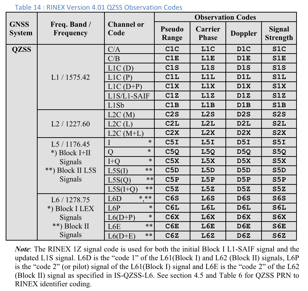
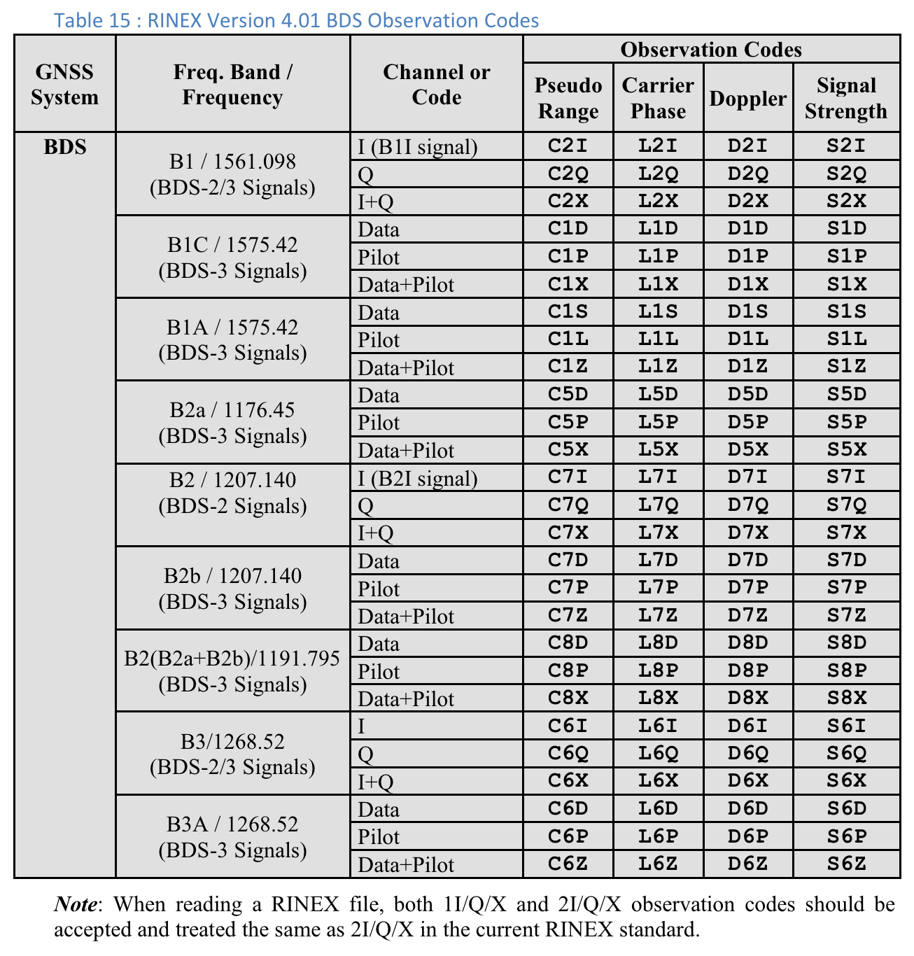
Códigos de observação RINEX 4.01
A última das três letras nos códigos de observação RINEX na coluna Pseudo Range é o valor Code type mostrado na tela Measurements no GnssLogger.
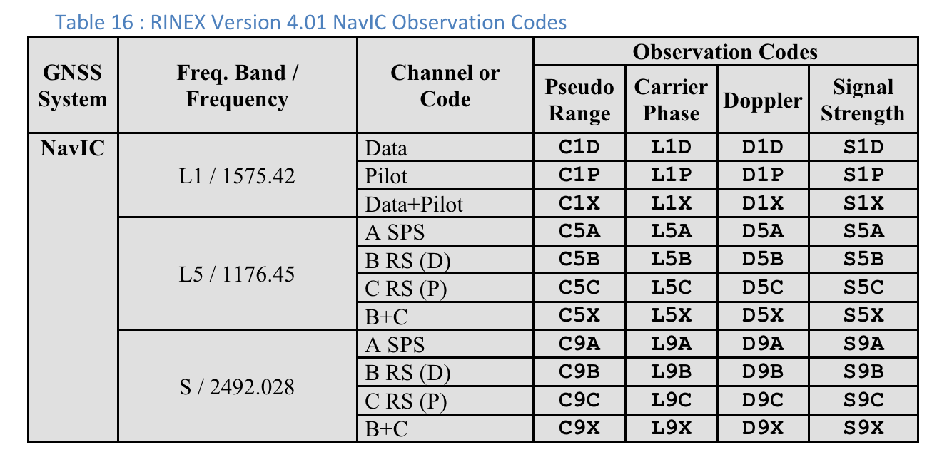
Confira a seguir as tabelas da especificação RINEX 4.01 para sua conveniência.
Consulte a especificação completa para mais detalhes.
Figura 4. Tabela 10: códigos de observação do GPS do RINEX versão 4.01Figura 5. Tabela 11: códigos de observação do RINEX da versão 4.01 do GLONASSFigura 6. Tabela 12: códigos de observação do RINEX versão 4.01 GalileoFigura 7. Tabela 13: códigos de observação do SBAS do RINEX, versão 4.01Figura 8. Tabela 14: códigos de observação do QZSS do RINEX, versão 4.01Figura 9. Tabela 15: Códigos de observação do BDS do RINEX versão 4.01Figura 10. RINEX Version 4.01 NavIC Observation Codes
O conteúdo e os exemplos de código nesta página estão sujeitos às licenças descritas na Licença de conteúdo. Java e OpenJDK são marcas registradas da Oracle e/ou suas afiliadas.
Última atualização 2025-07-27 UTC.
[[["Fácil de entender","easyToUnderstand","thumb-up"],["Meu problema foi resolvido","solvedMyProblem","thumb-up"],["Outro","otherUp","thumb-up"]],[["Não contém as informações de que eu preciso","missingTheInformationINeed","thumb-down"],["Muito complicado / etapas demais","tooComplicatedTooManySteps","thumb-down"],["Desatualizado","outOfDate","thumb-down"],["Problema na tradução","translationIssue","thumb-down"],["Problema com as amostras / o código","samplesCodeIssue","thumb-down"],["Outro","otherDown","thumb-down"]],["Última atualização 2025-07-27 UTC."],[],[],null,["# Analyze raw measurements with GnssLogger\n\nWith GnssLogger v3.1, users can view and analyze raw GNSS data on the\n**Measurements** screen.\n\nHere is the **Measurements** screen, followed by a few tips\nand tricks to make the most out of this data:\n**Figure 1.** Measurements screen\n\nIn the top card:\n\n- The top left shows the GNSS clock data (corresponding to [`GnssClock`](/reference/android/location/GnssClock)).\n- The top right shows the count of GNSS hardware (HW) discontinuities (from [`GnssClock.getHardwareClockDiscontinuityCount`](/reference/android/location/GnssClock#getHardwareClockDiscontinuityCount%28%29)), which helps determine if duty-cycling is on or off. When this counter increments, it indicates that there was a disruption in the continuous observation of GNSS signals (e.g., [duty-cycling](https://barbeau.medium.com/gnss-interrupted-the-hidden-android-setting-you-need-to-know-d812d28a3821) is on). Further down, the card displays aggregate information for all measurements:\n - **# valid measurements** --- For a measurement to be considered valid, the [`STATE_CODE_LOCK`](/reference/android/location/GnssMeasurement#STATE_CODE_LOCK) and [`STATE_TOW_KNOWN`](/reference/android/location/GnssMeasurement#STATE_TOW_KNOWN) or [`STATE_TOW_DECODED`](/reference/android/location/GnssMeasurement#STATE_TOW_DECODED)) flags must be set in [`GnssMeasurement.getState`](/reference/android/location/GnssMeasurement#getState%28%29)().\n - **# usable accumulated delta range (ADR) --- For** ADR, or carrier phase, to be considered usable for positioning, the [`ADR_STATE_VALID`](/reference/android/location/GnssMeasurement#ADR_STATE_VALID) flag must be set and neither the [`ADR_STATE_RESET`](/reference/android/location/GnssMeasurement#ADR_STATE_RESET) nor the [`ADR_STATE_CYCLE_SLIP`](/reference/android/location/GnssMeasurement#ADR_STATE_CYCLE_SLIP) flags can be set in [`GnssMeasurement.getAccumulatedDeltaRangeState`](/reference/android/location/GnssMeasurement#getAccumulatedDeltaRangeState%28%29)().\n\nIf your device always reports 0 usable ADR, even when in open sky with\nduty-cycling disabled, that's a good indication that your\ndevice doesn't support carrier phase measurements that can be used for\nhigh-accuracy GNSS.\n\nIn the bottom card, each row represents an individual [`GnssMeasurement`](/reference/android/location/GnssMeasurement).\n\n- The **Code type** column shows the exact type of GNSS signal using the code types defined in [RINEX 4.01](https://www.igs.org/wg/rinex/). For example, the GPS L1 signals with code type \"C\", represent L1 C/A, as indicated by the last letter in the three character code in the RINEX tables. GPS L5 Q would similarly have a \"Q\" code type. See the tables for other GNSS constellations at the end of this document for reference.\n- In the **Rx SV Time (ns)** column, the text is green if the measurement is valid.\n- In the **State column** , the state is also green if the measurement is valid. State shows a human-readable version of the bitwise flags that are set in the [GnssMeasurement.getState()](/reference/android/location/GnssMeasurement#getState%28%29) field.\n\nProvide feedback on new features using our\n[public issue tracker](https://issuetracker.google.com/issues/new?component=313183&template=0).\n\n**Table 10 : RINEX Version 4.01 GPS Observation Codes**\n\nFor each measurement, the \"Code Type\" shown is the last letter of the \"Pseudo\nRange\" value defined in the RINEX 4.01 specification for the relevant GNSS\nsystem and carrier frequency. For example, \"C\" is used for GPS L1\n\\[C/A\\] while \"Q\" is used for GPS L5 Q.\n**Figure 2.** Table 10: RINEX Version 4.01 GPS Observation Codes\n\nUsers can scroll to the right to see additional columns for each measurement:\n**Figure 3.** Additional columns on the Measurements screen in Table 10.\n\n- **PRR** is the Pseudo Range Rate in meters per second from [GnssMeasurement.getPseudorangeRateMetersPerSecond()](/reference/android/location/GnssMeasurement#getPseudorangeRateMetersPerSecond())\n- The **ADR State** column shows the human-readable version of the bitwise flags set in the [GnssMeasurement.getAccumulatedDeltaRangeState()](/reference/android/location/GnssMeasurement#getAccumulatedDeltaRangeState%28%29) column. If the ADR is usable for positioning, the text in the **ADR (m)** and **ADR State** fields is green.\n\nRINEX 4.01 observation codes\n----------------------------\n\nThe last of the three letters in the RINEX observation codes in the Pseudo Range\ncolumn is the **Code type** value shown on the **Measurements** screen in\nGnssLogger.\n\nFollowing are tables from the [RINEX 4.01 spec](https://www.igs.org/wg/rinex/) for convenience.\nSee the full specification for details.\n**Figure 4.** Table 10: RINEX Version 4.01 GPS Observation Codes **Figure 5.** Table 11: RINEX Version 4.01 GLONASS Observation Codes **Figure 6.** Table 12: RINEX Version 4.01 Galileo Observation Codes **Figure 7.** Table 13: RINEX Version 4.01 SBAS Observation Codes **Figure 8.** Table 14: RINEX Version 4.01 QZSS Observation Codes **Figure 9.** Table 15: RINEX Version 4.01 BDS Observation Codes **Figure 10.** RINEX Version 4.01 NavIC Observation Codes"]]