الخرائط والأماكن
تنظيم صفحاتك في مجموعات
يمكنك حفظ المحتوى وتصنيفه حسب إعداداتك المفضّلة.

اسمح للمستخدمين باستكشاف العالم باستخدام الخرائط الغنية التي تقدمها Google.
يمكنك تحديد المواقع باستخدام علامات مخصصة، وزيادة بيانات الخريطة بتراكبات صور، وتضمين خريطة واحدة أو أكثر كأجزاء، وعرض تفاصيل حول نقاط الاهتمام القريبة، وغير ذلك الكثير.
حزمة تطوير البرامج بالاستناد إلى بيانات "خرائط Google"
تعتبر حزمة SDK الخاصة بخرائط Google لنظام التشغيل Android جزءًا من منصة خدمات Google Play وتتيح لك تضمين الخرائط ومعلومات الخرائط المخصصة في
تطبيقك. اتبع دليل البدء لإعداد خدمات Google Play
في مشروعك، ثم التعمّق في الميزات الرئيسية لحزمة SDK للخرائط.
إضافة خريطة إلى تطبيقك
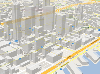
باستخدام حزمة تطوير البرامج بالاستناد إلى بيانات "خرائط Google" على أجهزة Android، يمكنك تضمين الخرائط في أحد الأنشطة كجزء باستخدام مقتطف XML. وتوفّر حزمة تطوير البرامج (SDK) هذه ميزات رائعة مثل الخرائط الثلاثية الأبعاد، والخرائط الداخلية، والأقمار الصناعية، والتضاريس، والخرائط المختلطة، والتقسيمات المستندة إلى المتجهات التي توفّر إمكانية التخزين المؤقت والرسم بكفاءة، وانتقالات الصور المتحركة وغيرها. تعرَّف على كيفية إضافة كائن خريطة.
تخصيص الخريطة
أضف علامات على الخريطة لتوضيح نقاط الاهتمام الخاصة للمستخدمين.
يمكنك تحديد ألوان أو أيقونات مخصصة لمحددات الخريطة لمطابقة شكل ومظهر تطبيقك. لتحسين التطبيق بشكل أكبر، ارسم خطوطًا متعدّدة ومضلّعات للإشارة إلى المسارات أو المناطق، أو وفِّر تراكبات صور كاملة. تعرّف على مزيد من المعلومات في
الدليل حول كيفية رسم العلامات.
التحكّم في طريقة عرض المستخدم
يمكنك منح المستخدمين رؤية مختلفة للعالم من خلال إمكانية التحكم في خصائص التدوير، والإمالة، والتكبير/التصغير، والتحريك في منظور "الكاميرا" على الخريطة.
تعرَّف على كيفية تغيير طريقة العرض.
إضافة ميزة "التجوّل الافتراضي" إلى تطبيقك
إضافة التجوّل الافتراضي إلى نشاط والسماح للمستخدمين باستكشاف العالم من خلال عروض بانورامية بزاوية 360 درجة. يمكنك التحكم آليًا في التكبير أو التصغير
والاتجاه (إمالة واتجاه) كاميرا "التجوّل الافتراضي"، وحرِّك
حركات الكاميرا على مدار مدة معيّنة.
واجهة برمجة تطبيقات الأماكن
ساعد المستخدمين في العثور على الأنشطة التجارية والمطاعم ونقاط الاهتمام الأخرى استنادًا إلى موقعهم الجغرافي الحالي. استخدم حزمة SDK الخاصة بالأماكن لنظام التشغيل Android لتوفير معلومات ملائمة وذات صلة مثل معلومات الاتصال وساعات العمل عندما يحتاج المستخدمون إلى هذه المعلومات.
يخضع كل من المحتوى وعيّنات التعليمات البرمجية في هذه الصفحة للتراخيص الموضحّة في ترخيص استخدام المحتوى. إنّ Java وOpenJDK هما علامتان تجاريتان مسجَّلتان لشركة Oracle و/أو الشركات التابعة لها.
تاريخ التعديل الأخير: 2025-07-27 (حسب التوقيت العالمي المتفَّق عليه)
[[["يسهُل فهم المحتوى.","easyToUnderstand","thumb-up"],["ساعَدني المحتوى في حلّ مشكلتي.","solvedMyProblem","thumb-up"],["غير ذلك","otherUp","thumb-up"]],[["لا يحتوي على المعلومات التي أحتاج إليها.","missingTheInformationINeed","thumb-down"],["الخطوات معقدة للغاية / كثيرة جدًا.","tooComplicatedTooManySteps","thumb-down"],["المحتوى قديم.","outOfDate","thumb-down"],["ثمة مشكلة في الترجمة.","translationIssue","thumb-down"],["مشكلة في العيّنات / التعليمات البرمجية","samplesCodeIssue","thumb-down"],["غير ذلك","otherDown","thumb-down"]],["تاريخ التعديل الأخير: 2025-07-27 (حسب التوقيت العالمي المتفَّق عليه)"],[],[],null,["# Maps and places\n\nAllow your users to explore the world with rich maps provided by Google.\nIdentify locations with custom markers, augment the map data with image\noverlays, embed one or more maps as fragments, show details about nearby points\nof interest, and much more.\n\nMaps SDK\n--------\n\nThe [Maps SDK for Android](https://developers.google.com/maps/documentation/android-sdk/) is part of the Google Play services\nplatform and lets you include maps and customized mapping information in your\napp. Follow the [Get Started](https://developers.google.com/maps/documentation/android-sdk/start) guide to set up Google Play services\nin your project, then dive into the key features of the Maps SDK.\n\n#### Add a map to your app\n\nWith Maps SDK for Android, you can embed maps into an activity as a fragment\nusing an XML snippet. This SDK offers exciting features such as 3D maps;\nindoor, satellite, terrain, and hybrid maps; vector-based tiles for efficient\ncaching and drawing; animated transitions; and much more. Learn about how to\n[add a map object](https://developers.google.com/maps/documentation/android-sdk/map).\n\n#### Customize the map\n\nAdd markers onto the map to indicate special points of interest for your users.\nYou can define custom colors or icons for your map markers to match your app's\nlook and feel. To further enhance the app, draw polylines and polygons to\nindicate paths or regions, or provide complete image overlays. Learn more in the\nguide about how to [draw markers](https://developers.google.com/maps/documentation/android-sdk/marker).\n\n#### Control the user's view\n\nGive your users a different view of the world with the ability to control the\nrotation, tilt, zoom, and pan properties of the \"camera\" perspective of the map.\nLearn how to [change the view](https://developers.google.com/maps/documentation/android-sdk/views).\n\n#### Add Street View to your app\n\n[Add Street View](https://developers.google.com/maps/documentation/android-sdk/streetview) into an activity and let your users explore\nthe world through panoramic 360-degree views. Programmatically control the zoom\nand orientation (tilt and bearing) of the Street View camera, and animate the\ncamera movements over a given duration.\n\nPlaces API\n----------\n\nHelp your users find businesses, restaurants, and other points of interest based\non their current location. Use the [Places SDK for Android](https://developers.google.com/maps/documentation/places/android-sdk)\nto provide convenient, relevant information like contact information and\nbusiness hours when your users need it."]]