Applicable XR devices This guidance helps you build experiences for these types of XR devices. [Learn about XR device types →](https://developer.android.com/develop/xr/devices.md.txt)  Wired XR Glasses [](https://developer.android.com/develop/xr/devices.md.txt#xr-glasses) [Learn about XR device types →](https://developer.android.com/develop/xr/devices.md.txt)
Geospatial anchors are a type of [anchor](https://developer.android.com/develop/xr/jetpack-xr-sdk/arcore/anchors.md.txt) that allow you to place 3D
content with geographical coordinates using the [Geospatial
API](https://developer.android.com/develop/xr/jetpack-xr-sdk/arcore/geospatial).
Geospatial anchors use a latitude and longitude to determine their positioning.
The latitude and longitude are defined by the [WGS84 specification](https://nsgreg.nga.mil/doc/view?i=4085),
which are the same coordinates shown in a typical GPS system.
## Determine the latitude and longitude of a location
If you have a specific point of interest in mind, use [Google Maps](https://www.google.com/maps)
to determine its latitude and longitude:
1. Go to [Google Maps](https://www.google.com/maps) on a desktop computer.
2. Navigate to **Layers \> More**.
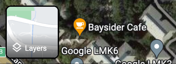
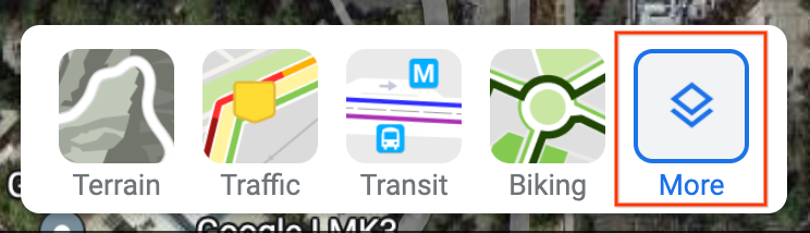
3. Change the **Map Type** to **Satellite** and clear the **Globe View**
checkbox at the bottom left corner of the screen.
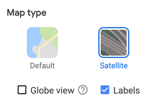
This forces a 2D perspective and eliminates possible errors that can come
from an angled 3D view.
4. On the map, right-click the location and select the longitude and
latitude to copy it to your clipboard.
## Convert a position in the user's area to a Geospatial anchor
If you are able to travel to the point of interest, you can determine the
latitude, longitude, and altitude from a local reading by [converting a
device-local pose to a Geospatial pose](https://developer.android.com/develop/xr/jetpack-xr-sdk/arcore/geospatial/positioning#local-to-geospatial).
## Position content at a Geospatial anchor
Geospatial anchors require an altitude value, which is relative to the WGS84
ellipsoid or relative to the terrain or rooftop.
- For altitude values relative to the WGS84 ellipsoid, use
[`Geospatial.createAnchor`](https://developer.android.com/reference/kotlin/androidx/xr/arcore/Geospatial.md.txt#createAnchor(kotlin.Double,kotlin.Double,kotlin.Double,androidx.xr.runtime.math.Quaternion)):
```kotlin
val createAnchorResult = geospatial.createAnchor(
latitude,
longitude,
altitude,
Quaternion.Identity,
)
```
- For altitude values relative to the terrain or a rooftop, use
[`Geospatial.createAnchorOnSurface`](https://developer.android.com/reference/kotlin/androidx/xr/arcore/Geospatial.md.txt#createAnchorOnSurface(kotlin.Double,kotlin.Double,kotlin.Double,androidx.xr.runtime.math.Quaternion,androidx.xr.arcore.Geospatial.Surface)),
using `GeospatialSurface.TERRAIN` and `GeospatialSurface.ROOFTOP`
respectively to specify how the final altitude should be interpreted:
```kotlin
val createAnchorResult = geospatial.createAnchorOnSurface(
latitude,
longitude,
altitude,
Quaternion.Identity,
GeospatialSurface.TERRAIN,
)
```
When using `GeospatialSurface.ROOFTOP`, the altitude defaults to the terrain
altitude when not placed on a building.
Then, check the result of the creation call:
```kotlin
when (createAnchorResult) {
is AnchorCreateSuccess -> {
// Use anchorCreateResult.anchor to render content at the result.
}
else -> {
// Anchor create failed.
// See AnchorCreateResult for possible failure reasons.
}
}
```
Finally, use the anchor to position 3D content:
### Compose XR
```kotlin
Subspace(FollowTarget.anchor(anchorCreateResult.anchor)) {
SpatialPanel {
GeospatialContent()
}
}
```
### SceneCore
```kotlin
val anchorSpace = AnchorSpace.create(session, anchorCreateResult.anchor)
val contentEntity = createGeospatialContentEntity(context, session)
anchorSpace.addChild(contentEntity)
```